If you just go for a paddle than you can stop thinking about wanting to go for a paddle.

Tuesday, June 28, 2011

2011: Post 21c – Long Island Trip – Day 3

I suggest you read entry 21a first, then entry 21b prior to reading this entry....

We awake at about 5:45 am on our last morning (Monday).  We were fogged in.  We couldn’t even see across Haystack Harbour to where the cabins were.  We had our breakfast and for the last time on this trip we broke down our camp and packed up our kayaks. 

Getting ready to leave Haysack Harbour
Leaving Haystack Harbour in the fog....

Tony

Hazen

Clyde
  
It was a leisurely paddle in the heavy fog.  Again the water was flat calm with no wind.  At one point along the way a crow took to wing from the cliffs in front of me and dropped something that landed about 6 meters off my bow and a little to the starboard.  I originally thought it was trying to poop on me and chuckled a little to myself after saying “you missed me.”   But the plop on the water surface was too pronounced.  I veered over a little and seen a small crab sinking down in the clear water. 


I paddled into one little cove while the guys crossed
its mouth.  It would not be hard to get lost in
the fog if you strayed too far from each other...

A short paddle of about 9 km brought us up to the east side of the same beach of where we had stopped for our first break after crossing from Arnolds Cove to Long island.  We hit the beach before too long about a kilometer from Long Island Point.  This would be the last place to have a break before the crossing in the fog.  I believe Tony has named this spot Welcome Cove.  Almost exactly two days earlier at about the same time in the morning we were taking a break on this beach on the west side after crossing from Bordeaux Island.

The last place to get off the water for a break
before getting back to Long Island point and
then the crossing back toward Arnolds Cove
With our last break over we got back on the water and paddled to the end of Long Island.  We paddled around a rock that is there to ensure it was a true circumnavigation and then turned kayaks into the fog.  Earlier, Hazen had taken a bearing from Long Island Point to the left side of Bordeaux Island.  It is about a 6 km crossing on a magnetic bearing of approximately 58 degrees, and we anticipated it would take us about 50 minutes (as a group we were generally paddling around 7 km an hour on flat calm water) if we stayed on our bearing to hit Bordeaux island.  We decided we would not use our GPS’s to make the crossing for the practice.  As long as we stayed more or less on our bearing we would hit land somewhere.  If after one hour of paddling we had not hit land we would then consult our GPS’s to see where we were and then make corrections as needed.

We took turns leading.  It was my first crossing in fog and was an interesting experience.  When I was leading I stayed on our chosen bearing but I kept wondering if I was actually going straight.  I had the sensation I was going in a curve and wanted to follow my instinct to veer to the right or left, but I stayed on the bearing…  ‘trust the compass’ Tony had said somewhere along the way.  In less than an hour the side of Bordeaux Island suddenly loomed out of the fog.  We had hit our target about as dead on as you can in the time expected.  I checked my GPS and found that our track was laid directly on top of the track of when we crossed on Saturday morning when we were able to see.  About another 4 km and we would be back where we had started in Arnolds Cove.

The guys inside Arnold's Cove...
not far to the starting point now...

I think we were all glad to hit the beach, I know I was, it had been a long weekend. 

Hazen hits the beach...
... then Clyde,
... and then Tony.

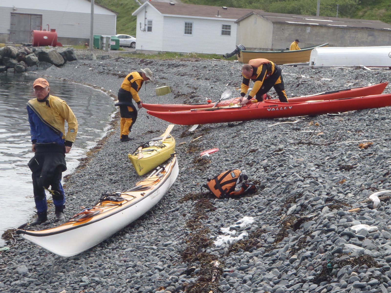
I checked my GPS for the last time and we had paddled 21.3 km for the day; a short paddle only when compared to the distance covered on each of the last two days.   Per my GPS we had covered 93.13 km over the last three days.  We unpacked, loaded the gear back into the cars, and then loaded the kayaks onto the roof racks.  We took the short drive to Megans Restaurant on the highway and had a wonderful lunch of fish and chips and then took the sleepy 1.5 hour drive back home to St. John’s.

My final thoughts on this trip:

This island is a great destination for a kayak trip, but because of the required crossing it becomes a multi-day camping trip, otherwise you cannot see much of the island.  Although we did a circumnavigation and crossing over and back (totaling 93 km) in three days, I would have preferred to have had another day or even two.  A couple more days on the trip would allow the daily paddling lengths to be shortened, allow more time to explore in more detail the sheltered coves of Buffet Harbour and Port Royal Arm, and maybe even visit the little islands nearby.  A night camping in Harbour Buffet would have been nice, or even to be able to spend a half day wondering around there would be great.  We did a good job in covering the coast line and coves of Long Island, but we had a couple of long paddling days to do it. 

During our trip we saw eagles, caribou, caplin, otters, a horse, sheep, and even three dogs belonging to cabin owners.  Anybody you might encounter staying there are very friendly and genuinely excited about having kayakers visit them.  There are many beaches to put-in on for breaks and a lot of them will allow for camping sites.  There are small brooks flowing to the shore here and there that will allow you to obtain freshwater, although I would recommend treating it for the sake of good health.

Of course, like any multi-day kayaking trip, you need to be sure of the weather forecast before you go and get it if you can during the trip.  We were not able to get the weather on VHF radio when we tried, but cell phone coverage was achievable in the locations that were tried, namely in Port Royal Cove and Haystack Harbor, where our campsites were located, as well as Harbour Buffet... so you can make a phone call home and to get weather updates.


I definitely would rate this destination 5 out of 5 Greenland paddles.

2011: Post 21b – Long Island Trip – Day 2

I suggest you read entry 21a prior to reading this entry...

I slept better than the night before.  About 5:30 am I heard a longish ziiiiiip and then Tony’s voice saying “awesome” (sounding like ahhhhhh-sum).  Then a few seconds later I detected a camera flash through the screen of my tent door and wondered what it that was that was so awesome to Tony first thing this morning.  I got out and looked down the beach to see the horse looking at us and a sheep near it, half out of the woods.   Tony said there were several sheep there with the horse when he got out of his tent.  That is indeed an awesome sight to see first thing in the morning when you crawl out of your tent! 

Not a great pic but here is the horse.  The sheep was
gone by the time I got my camera.

Breakfast on Day 2

By about 7:30 am we had finished our breakfast, broke camp, repacked the kayaks and were leaving the beach.

From our campsite at Port Royal Cove it is about 7 km to get to Buffet Head, the southern end of Long Island.  Along the way there was one spot where we saw a couple eagles flying out of a little spot hidden to our view.  As we kept paddling more eagles kept flying out of the same spot.  By the time they stopped appearing Hazen said he had counted nine eagles.  It was exciting to see so many at the same time.  I pulled into the spot that they came out of and it was just sort of an indentation in the cliff.  Of course, with camera off to save on battery, there was no picture to be had of the eagles. 

We approached Buffet Head after about an hour of paddling into a bit of a headwind.   I was feeling a sense of accomplishment to have paddled the west side of Long Island from tip to tip; almost exactly 24 hours ago we had just been leaving Arnolds Cove! 

Clyde at Buffet Head with Iron Island behind him.

Tony and Hazen closer to the shore at Buffet Head.

As we rounded the head there were a lot of gulls in a bit of frenzy in a small cove.  We paddled over to see exactly what the fuss was about.  It was another treat to see schools of caplin under our hulls!  If we were so inclined we could have easily managed to get a meal. 

Not a clear shot, I submerged my camera and hoped for the best...
We rounded the head and continued up the coast.  The water became nearly flat calm again.  There were more eagles and I decided I just had to try to get a picture of one.  I turned on my camera and left it on for a while.  Before too long one flew out and I did get a shot. 

My only shot of one of the many eagles we seen over the weekend

We kept paddling in the calm water and entered Buffet Harbour by mid-morning by way through The Tickles. There was an old rusted ship beached across from the old community, where just cabins and remnants of the old building now stand.  You can get a sense of the size of the ship as Clyde paddles along the side of it.


Harbour Buffet was an interesting stop.  It is very sheltered from the Eastern Channel in Placentia Bay.  Tony went to visit the people that Hazen had visited the night before.  The rest of us walked down the beach and into the woods and came across a concrete foundation of a long ago house, which I found to be very interesting.  There is a concrete walkway leading from what must have been a path or little road at one time to the front of the building.  There are flower’s growing on one side (I believe Tony called them Paper Whites) where I imagine was a flower garden at one time, and there is a set of concrete steps on the same side, still intact.  On the other side of the building they had poured a concrete retaining wall with part of it curved.  The straight part of the retaining wall has been pushed out of plumb by the pressures of the earth behind it, but the curved portion is still dutifully doing its intended purpose.  We surmised the amount of work it must have taken to haul bags of cement from the water edge, gathering and hauling fresh water, sand and stone to the site, and then mixing and placing the concrete in the forms, the mixing likely done by hand at that time.   

Paper Whites growing in the garden...
Concrete steps still intact...
The concrete retaining wall on the other side of the
foundation...  the curve is a nice feature.
Standing where the front door would have been, here is
the concrete walkway leading away from the house
We heard Tony calling out for us after a while and we called him over to have a look at the foundation.  He told us the people he had visited had put on coffee for us if we wanted it.  The four of us walked a little farther and came to a little shack with a sign inside telling us the name of it was “The Possum Lodge.”

The Possum Lodge framed in de-barked logs...
Inside the lodge...
I wonder if Red Green ever comes to visit...
bow your heads for the man's prayer...

I'm a man,
but I can change,
if I have to,
I guess...

We went back to our kayaks and decided to go for that coffee.  As is always the case in little Newfoundland communities (even the cabin communities) people are always happy to have visitors drop by.  These people (I do not know their names) did not have a cabin but instead stayed on their boat while there. 

The Missus of the boat passing out greatly appreciated cups of coffee...

One fellow said there was a cabin in Hay Cove, told us it was unlocked, and we could go ahead and use it; I believe he may have owned it, or it belonged to his family...  We said our good-byes and paddled the 5 or 6 km to Hay Cove where we stopped for lunch. 

Hay Cove lunch spot

Cooking and eating lunch on the beach is just fine, but it was a comfort to be able to cook our lunch inside and sit on a chair at a table and eat. 

Clyde and Hazen really roughing it in comfort

Tony made up a batch of bannock and shared with us…. I joked he reminded me of my grandmother as he kneaded the dough; I wish I would have had an apron for him...

Grandma Tony kneading away...

Now I do not mind roughing it.  But it is nice to enjoy a little comfort now and then as you are roughing it.  This cabin at Hay Cove came complete with a traditional outhouse.  I don’t need to say any more about that topic.

A welcome site for a paddler...

Leaving Hay Cove we paddled another 9 km to Southwest Cove where we had another break on a beach.  When we got back on the water we paddled along the shore and as we got abreast of an island called Shag Roost we could see a hole in the middle of it and wondered if we could paddle through it. 

Clyde nears the hole in the island

We paddled over but the tide level was too low, maybe it could be done at higher tide.  So Hazen paddled around so we could at least get a shot of him through the hole. 

Clyde tried to get Hazen to get out of his kayak so
we could get a shot of him standing in the hole...

Tony, having a background in geology, pointed out how the striations of rock stopped on one side of where this hole is (about 3 or 4 meters each side of the hole) and then continued on the other side… there was some kind of fracture in the original rock eons ago that was filled in with a different material.  If you look closely you can see this formation in the picture... 

Geology lesson 101..  we often get to learn about
such things when Tony paddles with us 

From there it was only a couple more kilometers and we reached our destination of Haystack Harbour.  Hazen, Clyde, and I stopped to talk to some older people there who said they lived in the cove from March to November every year! 

Clyde saying hello to the inhabitants of Haystack Harbour

Tony continued to the beach at the end of the cove and scouted out a campsite, and we joined him a little while later.  I hit the beach and checked my GPS – 34.5 km for the day.  It was around supper time then.  Just as we got our tents set up it started to rain a little – the first rain of the weekend.  We tied up a tarp in the trees and had a nice dry place to cook our supper. 

Nice and dry under our tarp

Again we gathered up some wood for that night’s campfire.  We had misty rain but it did not dampen our spirits.  I broke out my storm cag and was warm and dry.  Tony held true to his campfire policy and we soon had another excellent blaze on the go.   

Tony looking for the next piece of fuel....
A couple drinks of rum for me and Clyde, scotch for Hazen, and wine for Tony, and then we turned in for the night after the fire burned down.  I slept very well, snug and warm in my tent.

2011: Post 21a – Long Island Trip – Day 1

Last weekend Clyde, Tony, Hazen, and I circumnavigated Great Colinet Island (see Post 20).  Little did we know it would be a precursor for the following weekend to take on a much larger island.  Early in the week the possibility of a camping trip to Long Island in Placentia Bay came up, with the intention to circumnavigate it. 

Long Island in Placentia Bay

This island is approximately 60 km around, not including paddling around all the coves that it has. You can easily add on 10 or 15 km to that distance, depending on how deep you decide to go into the coves.  We ended up with the same four guys committing to this trip.

The original intention was to drive to Arnold’s Cove on Friday June 24th, do the 10 km crossing to Long Island, paddle another 5 km to Spencer’s Cove and set up camp.  Then we would have Saturday, Sunday, and Monday to paddle the additional 60 km around the island, and the 10 km crossing back to the put-in.  But three of the four of us work and we all just could not get away early enough on Friday.  So it seemed like we may not have enough time to actually circumnavigate but we decided to go for the weekend and at least get to the island and get in some paddling and camping for the 3-day long weekend.

Friday after work Clyde picked me up, and Hazen picked up Tony.  We all met at the Irving on the TCH about 6 pm.  We drove the short 1.5 hours to Arnold’s Cove and scouted around for possible campsite for the night and a put-in location for Saturday morning.  We ended up camping off the highway for the night. I did not take any pictures on Friday night as I wanted to save my battery life for the paddling trip. 

We were up about 5:30 am Saturday morning.  We were no longer on the clock and took our time with breakfast and breaking camp and headed back to Arnold’s Cove.  By 8:30ish the boats were packed and we left the beach.

Arnolds Cove put-in
Looking toward Long Island just after the put-in

We paddled to Bordeaux Island and, as it was a nice calm morning, we decided to do a straight crossing to Long Island Point instead of by way of Bread and Cheese Islands off the north end of Long Island. 

Arriving at Long Island Point

After the crossing we headed into Central Channel, paddled another kilometer and had our first rest stop.  The plan was to paddle as far as Hennesy Cove, about 15 km from Long Island Point, giving us a daily total of about 25 km.  Then we would assess and decide how much farther we would go for the day, but we talked about going as far as the resettled community of Kingwell.

Our first rest stop.
This side of the beach faces Merasheen Island.  If you walk
a few meters east you will be looking across Eastern Channel.

Continuing southward from our first rest spot we paddled into Spensers Cove and encountered a few cabins on the site of the resettled community.  There once were fishing settlements on Long Island, but they were resettled many years ago.  Some people maintain cabins here and there on the island, generally in the old community sites, and some still use these areas as a base for their commercial fishing operations (I think mainly, perhaps only, lobster fishing).   

The guys talking to people in Spencers Cove

We paddled farther and by the time we had paddled 19 km since leaving Arnolds cove it was lunch time and we decided to stop and refuel.

Lunch stop

After lunch we paddled onward.  It was such a calm, beautiful day.  We were lucky and it was easy paddling and we made good time.  In one of the coves (I believe it was Hennesy Cove) that we saw four or five caribou. That was an unexpected treat. They were too fast retreating into the trees and I didn’t get a picture.  All along the way we would see eagles but I did not get any shots of them either.  The next day a fellow in Harbour Buffet told us that Merasheen Island had been populated with caribou some time ago and some eventually swam over to Long Island; there were even licenses available to hunt them on both of the islands!  Also, he said that the island was a prime place to see lots of eagles.

Along the way there we many things to take pictures of, but with limited battery life you had to choose your subject matter.  But we did encounter a square-ish hole in the cliffs that I thought was interesting. 

It's a little hard to see at first glance but
there is as square hole in the rocks...

A little farther along I was in closer to shore and came across a group of four otters that were hanging out on the shore.  Only one decided to pose for me by the time I got my camera out, turned on, and zoomed in. 

Here is one of the four otters I saw

About 7 km past Hennesy Cove we turned the point and headed another kilometer north to the community of Kingwell.  We floated for a few minutes talking to a lady staying in a cabin there.   She asked where we had come from and was awed to hear we had paddled from Arnold’s Cove that morning. It was about 4 pm at that point and we were ready to find a place to set up camp and have supper.  We paddled around a little island near her cabin so we could at least have a look up the cove and then we headed south again toward Port Royal.  We pulled up in a little cove to scout out a campsite.  We climbed up a steep bank and then walked a hundred meters or so and were able to see into a cove on the other side (named Port Royal Cove on my map).  It was a much better spot to stop for the night and we jumped into our kayaks and paddled the extra kilometer.

...looking down from our contemplated campsite.
You can see a couple of the small islands between
Port Royal Arm and Central Channel with Merasheen
Island in the background.

We could see a horse a little farther down the beach from where we intended to land; there isn’t just wild life on this island...  It was somewhere around 5 pm or so when we hit the beach, we had paddled 37.2 km that day (per my GPS), and I was glad to be done.  Prior to this day my daily personal best was a 30 km paddle.  

We set up camp and got supper on the go.  Hazen decided he would go for a walk to visit Harbour Buffet (directly across on the other side of where we were camping) and the rest of us combed the beach for fuel for our campfire that night. 

Supper time in Port Royal Cove

It became clear to me that Tony’s policy regarding campfires is that ‘if you are going to spend the time and effort to gather up the firewood it was going to be burned.’  We started the fire just before Hazen came back from his visit and had a fine blaze to enjoy along with a couple drinks.

A fine campfire, compliments of Tony's efforts 

Like during the day, there was no wind and the water remained very calm.  A southwest wind was supposed to come up by noon on Sunday.  We made the decision that the next day we would continue around the island with the intention to paddle as far as Haystack Harbor.  By noon we would be well on our way up the other side of the island and a southwest wind would be in our back to push us along.  We turned into our tents after the fire burned down and said our good nights to John-boy, Grandpa, and Mary Ellen…

Saturday, June 18, 2011

2011: Post 20 – Chicks on the beach, seals on the rocks

Clyde has wanted to paddle around Great Colinet Island in St. Mary’s Bay for a while now - I’ve heard him mention it several times.  The weather forecast looked good for today.  Tony e-mailed a bunch of us, but only Hazen, Clyde, and myself accepted.  What a day it was... I can see why they put ‘Great’ in front of the islands name…


Once Tony pulled up his skirt, and the rest of us finished packing our kayaks we headed straight across to the island...


There was no wind as we crossed the 1.5 kilometers to the island...


We agreed we would do a true circumnavigation and come back to the same spot before crossing back to Admirals Cove.  We all touched our bows off a beach after the crossing and then turned toward Mosquito Cove.  There wasn't much swell and wave action but there were lots of places to do some rock-hopping...


At one spot Hazen ended up sitting a little dry for a while...


There were lots of little caves and overhangs along the way...


When we got to Mosquito Cove we got out and walked around for a while.  There were a few cabins there but I thought the log cabin bird house was very interesting, although the tenants do need to do a little repair on the roof....


We did find some action here and there as we paddled along.  Hazen and Clyde are behind this wave...


By 1 pm we were at Wild Cove and got out to have our lunch.  With bellies filled we walked down the beach to check out potential future camp-sites.  There were some nests here and there, some with just one egg, some with several eggs, and some with none...


And there were even a few chicks on the beach (we did not bother them, only snapped a quick picture)....


The highlight of the day for me were the seals on the rocks.  We seen the head of one or two bobbing in the water along the way.  But at one point I seen a few on the rock so I took a quick picture.  As I sat looking at them I realized there were about a dozen sitting there.....


I decided to try to move a little closer for a better shot.  As I slowly paddled closer some of them took to the water to keep an eye on me...


I zoomed in my camera as far as it would go for a closer shot...


I just let the water push me along and snapped off a last shot...


In another little cove farther along I seen 4 or 5 more seals sitting on a rock but I did not have my camera turned on and didn't get any pictures of them.  I seen about 20 seals on our paddle today.  Sometimes you see one or two now and then, once before I seen four heads bobbing on the water looking at me.  But today was the first time I've seen so many on a paddle. 

From put-in to take-out at Admirals Beach our trip was just under 6.5 hours long, and we covered 25.92 kilometers (per my GPS).  Add in the drive (about 1.25 hrs each way) and time spent loading up the car in the morning, meeting the other guys, and gearing up and down at the launch-site, and this trip becomes a full day commitment.  But what a day it was!